
78 George Anson - Map of Peru - Plan of Paita
Description
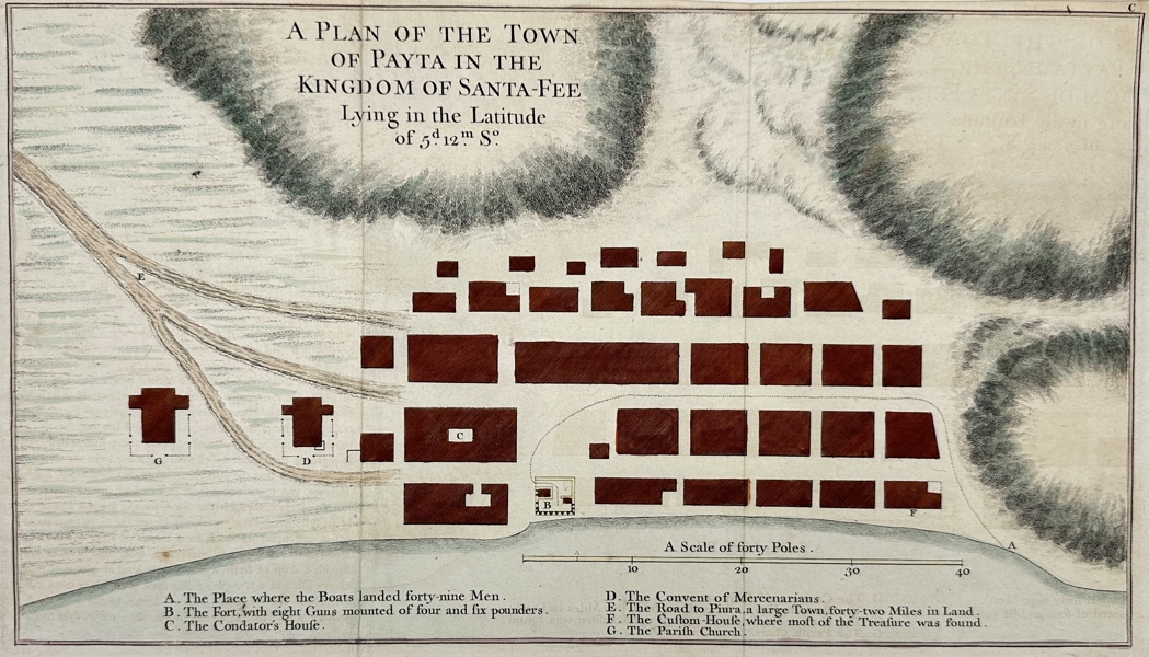
A Plan of the Town of Payta in the Kingdom of Santa-Fee. Detailed plan of PAITA, in northern Peru, a key stop for the Spanish treasure galleons sailing north from the port of Callao (Lima) to Acapulco. By the English pirate (‘Baron’) George Anson. Published in 1749, description of his around the world voyage from 1740-1744. From ‘Voyage Autour de Monde’. Amsterdam, copper plate engraved. His ‘mission’ was to attack Spanish territories in western South America and engage and loot Spanish treasure galleons. If caught the Spanish would have convicted him of piracy and executed him and his crew. A different undertaking in which he lost two thirds of his crew and three of his six ships, leaving only 335 crew for the remaining voyage. His determined efforts finally saw major success when the larger and better armed Spanish treasure galleon ‘Nuestra Senora de Cobadonga’ was captured in 1743 off cape Espiritu Santo, Samar island of the Philippines. Eventually only one ship, his flags the ‘Centurion’ and just 125 crewmen remained when they returned to England in 1744. He was promoted to Lord by the British government and was one of the top English commanders during the Seven Years War.
Artist of Maker
George Anson
Medium
Engraving
Date
1749
- Condition:This work is in good condition overall, there may be a few minor imperfections or fox or mottled marks to be expected with age. Please review the images carefully for condition details, and feel free to contact us with any questions or for a comprehensive condition report.
- Dimensions:45 cm x 25 cm
| Estimate | 1,000 - 2,000 SEK |
| Buyers Premium (inc. VAT) | 25% |
| Hammer Fee (inc. VAT) | 60 SEK |

Dahlströms Fine Art
Kristinaplatsen 3
60231 Norrköping
+46 70 359 75 85


© Software Copyright 2024 Skeleton. All rights reserved.