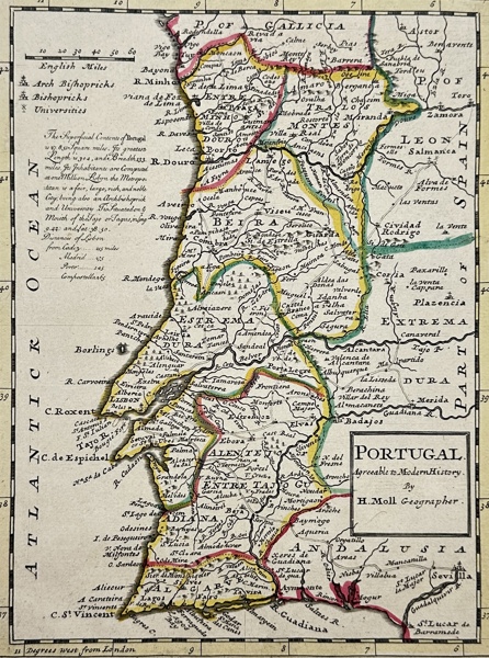
84 Herman Moll - Map of Portugal - Portugal Agreeable to Modern History
Description
Portugal Agreeable to Modern History is an excellent map of Portugal by geographer Herman Moll published in 1729. Moll, based in London, was one of the most influential cartographers of his time.
The map provides a detailed representation of Portugal, distinguishing its territories based on ecclesiastical hierarchy - Archbishoprics and Bishoprics. It also marks the locations of the country's Universities.
Herman Moll (c. 1654-1732) was one of the most important London mapmakers in the first half of the eighteenth century. Moll was probably born in Bremen, Germany, around 1654. He moved to London to escape the Scanian Wars. His earliest work was as an engraver for Moses Pitt on the production of the English Atlas, a failed work which landed Pitt in debtor's prison. Moll also engraved for Sir Jonas Moore, Grenville Collins, John Adair, and the Seller & Price firm. He published his first original maps in the early 1680s and had set up his own shop by the 1690s.
Artist of Maker
Herman Moll
Medium
Engraving
Date
1729
- Condition:This work is in good condition overall, there may be a few minor imperfections or fox or mottled marks to be expected with age. Please review the images carefully for condition details, and feel free to contact us with any questions or for a comprehensive condition report.
- Dimensions:20 cm x 26 cm
| Estimate | 1,000 - 2,000 SEK |
| Buyers Premium (inc. VAT) | 24.4% |
| Hammer Fee (inc. VAT) | 59 SEK |

Dahlströms Rare Prints
Harju maakond, Tallinn
Lasnamäe linnaosa, Ruunaoja tn 3, 11415
Estland
+46 70 359 75 85
info@dahlstromsfineart.se


© Software Copyright 2025 Skeleton. All rights reserved.